🚀 A New Era in Earth Observation Begins
The global scientific community is abuzz with anticipation as NASA and ISRO (Indian Space Research Organisation) gear up for the launch of NISAR, one of the most advanced Earth-observation satellites ever built. The satellite, which has a price tag of $1.5 billion, is expected to launch in July 2025 from Satish Dhawan Space Centre in India. The mission marks a milestone in international cooperation and the evolution of satellite technology for monitoring our planet in unprecedented detail.
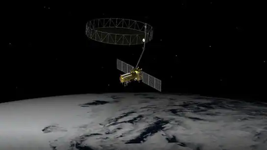
NISAR, short for NASA-ISRO Synthetic Aperture Radar, is more than just another satellite—it’s a scientific powerhouse designed to study the most critical natural phenomena affecting Earth’s surface. Its ability to detect subtle ground movements down to a few centimeters sets it apart from all previous Earth observation missions.
🌐 What Is NISAR and Why Is It So Important?
NISAR is the first Earth-observing mission to use two different radar frequencies (L-band and S-band) for comprehensive and consistent global coverage. This dual radar configuration allows it to monitor land surface changes, glacial movements, volcanic activity, forest degradation, agricultural productivity, and disaster impact zones with high accuracy.
It will orbit Earth every 12 days, collecting massive volumes of data that can be used to analyze both natural and human-induced changes across the globe. By doing so, NISAR will not only support scientific research but also help in early warning systems, climate risk modeling, and infrastructure planning.
The satellite will make repetitive measurements of the planet’s surface deformation and biomass, key indicators of ecological health and geological stress. From earthquakes to urban expansion, NISAR will track it all.
🇮🇳🇺🇸 A Symbol of Indo-US Space Cooperation
This mission is an extraordinary example of collaboration between two of the world’s leading space agencies—NASA and ISRO. While NASA provided the L-band SAR (Synthetic Aperture Radar) system, ISRO contributed the S-band SAR, satellite bus, launch vehicle, and ground systems.
With India managing the satellite's launch and much of its infrastructure, and the United States providing key radar and support systems, the NISAR project reflects a balanced and strategic partnership that is expected to extend beyond this mission.
This joint effort also paves the way for future science diplomacy and deeper cooperation in space exploration, resource monitoring, and technological exchange.
📊 Scientific Capabilities and Expected Benefits
🔬 Measuring Ground Deformations
NISAR’s radar imaging technology will allow scientists to track extremely small changes in the Earth’s crust. This is vital for understanding and predicting earthquakes, volcanoes, landslides, and subsidence in urban zones. It provides the kind of data that can save lives and reduce property damage by informing building codes and early warning alerts.
🌲 Monitoring Forests and Carbon Emissions
By scanning forest canopies and estimating biomass, NISAR helps in tracking carbon sinks, essential in the fight against climate change. Accurate biomass data aids global environmental commitments like REDD+ and helps verify climate pledges and conservation efforts.
🌊 Tracking Glacial Retreat and Sea-Level Rise
Glaciers and ice sheets are major contributors to sea-level rise. NISAR will monitor ice movement in regions like Greenland, Antarctica, and the Himalayas, offering a clearer picture of how quickly these frozen giants are melting—and what that means for coastal populations.
🌾 Agricultural Health and Productivity
For farmers and policymakers, NISAR’s insights into soil moisture, crop growth, and seasonal changes will be critical in ensuring food security and effective resource management. It can help detect early signs of drought, flooding, or pest outbreaks, allowing for timely interventions.
🛰️ Advanced Technology on Board
NISAR combines the strengths of L-band SAR (long wavelength, can penetrate vegetation and soil) and S-band SAR (shorter wavelength, ideal for finer surface observations). This unique combination allows it to image all weather conditions, day or night, over land and water.
Its onboard data processing units, solid-state recorders, and adaptive antenna systems make it capable of handling massive data streams. The satellite will transmit terabytes of information to ground stations across India and the US, which will be shared freely with global researchers.
This level of open-source scientific data sharing is key to accelerating research in geoscience, climate studies, and emergency response systems.
📅 Countdown to Launch
The mission is now in its final testing and integration phase, with teams at ISRO’s launch facility and NASA's Jet Propulsion Laboratory ensuring everything is mission-ready. The satellite is scheduled for launch aboard the GSLV Mk II rocket in mid-July 2025, following multiple successful simulations and joint system checks.
Upon reaching its final sun-synchronous orbit about 747 kilometers above Earth, NISAR will undergo a brief commissioning phase before beginning its planned three-year mission, which may be extended depending on system health.
💡 How NISAR Data Will Be Used Around the World
Data collected by NISAR will be made publicly available, serving a wide spectrum of users—from scientists and environmentalists to urban planners, governments, NGOs, and educators.
Here are some of the ways different groups will benefit:
Governments will use NISAR data to plan safer cities, monitor illegal mining, and respond to natural disasters more efficiently.
Climate researchers will get refined data models for studying global warming trends.
Farmers and food agencies will access regional agricultural insights for smarter decisions.
Geologists will use it to monitor fault lines and tectonic activity in earthquake-prone regions.
Humanitarian agencies will assess damage from floods or conflicts faster and plan recovery missions more effectively.
🌎 A Step Toward Sustainable Planet Management
In an age of worsening climate crises, rising sea levels, and ecological imbalance, missions like NISAR represent a giant leap toward managing Earth more responsibly. It’s not just about watching the Earth—it’s about understanding it, protecting it, and planning for its future.
The NISAR satellite serves as a critical tool in global efforts to track and mitigate the effects of climate change, natural hazards, and resource mismanagement. With continuous monitoring, we can finally connect the dots between environmental signals and policy actions.
📣 Final Thoughts
As the world watches the sky this July, the launch of NISAR will mark not just a technical achievement, but a profound shift in how we study and respond to changes on Earth. With cutting-edge tech, collaborative spirit, and a shared vision, NASA and ISRO are offering the world a bird’s-eye view of the future.
For science lovers, environmentalists, and global leaders alike, NISAR is more than a mission—it’s a movement toward better stewardship of our only home.


Comments 0